Overview
The Temperate Program (TP) of ForestGEO consists of an ever-expanding network of nearly 20 forest plots in five countries on three continents. These plots were established through public and private funding sources, the involvement of many institutions, numerous scientists, and the labor of technicians, students, interns, and volunteers. Although each plot has its own origin story, unique biological and physical features, and focal research programs, as a network these sites promote synthetic research in forest ecology across a wide range of biomes, biodiversity levels, climates, stand ages and land-use histories.
Overarching research themes across this network include forest demography (the growth, survival, and recruitment of trees), canopy and vegetative structure and patterning, biogeochemistry, forest response to climate change, invasions biology, floristic phylogenetic and taxonomic diversity, plant-animal interactions, and the role of human and natural disturbances in forest development and dynamics. Most of the plots carry a strong legacy of research programs that directly add to their value and potential in the broader ForestGEO network. This network is well positioned in the National Ecological Observatory Network (NEON) with three NEON regional core sites and one satellite site.
The primary goal of the TPN is to foster synthetic research of temperate and boreal forest systems. The standardized protocol of ForestGEO forms the basis for these comparisons, but the research partners constitute the critical engine to this research. Goals of the TPN for pre-existing plots include the common communication of research interests across site scientists, the submission of proposals for funding research across sites and for recensus of current sites, and the publication of papers that involve data (both ForestGEO data as well as other data gathered on-site in the past or through different programs) that involve multiple TPN sites.
Primary Scientific Aims
- The detailed study of forest growth, mortality, and recruitment in a changing climate.
- Carbon movement through forest ecosystems and the interface between terrestrial systems and the atmosphere.
- The use of forest research to inform earth systems models of climate and terrestrial biomes.
- The dynamics of stand history and assembly in creating past, current, and future patterns of forest biodiversity, phenology, and biogeochemical cycling.
- Fostering a network ‘laboratory’ through which these aims and others can be pursued through collaborative research funded through national and international funding programs.
In 2012, five new plots were added to the TPN, spanning a diversity of sites, scientists, and research potential.
The University of California Santa Cruz Forest Ecology Research Plot (UCSC-FERP), marks an extension of a teaching plot adjacent to UCSC.
The Zofín Forest Dynamics Plot, in southern Czech Republic, is a 25 ha. plot set within a larger research plot (75 ha.) that has had stems >10cm DBH measured since 1972.
The Indiana University Forest Dynamics Plot (IUFDP) is located at Indiana University’s Lilly Dickey Woods in Nashville, Indiana. This 25 ha. plot is an expansion of a research plot installed by Dan Johnson in 2009-2010.
2013 saw a new plot at the Tyson Research Center (TRC-FDP), established to study drought effects on forests. This plot, run by Jonathan Myers (Washington University, St. Louis) consists of 25 ha. of hardwood forest in the northern Ozark Mountains in Missouri. Interestingly, four ha of this plot were first installed in 1981, following the published protocol that Stephen Hubbell and Robin Foster implemented at the ForestGEO network’s first site at BCI, Panama.
Boreal Network
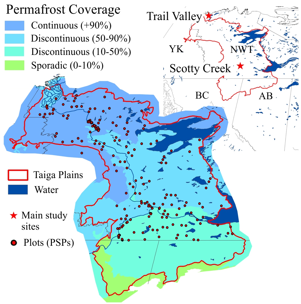
The potential to build a boreal network is worth considering now, especially as such plots might quickly translate into sources of substantial funding (e.g., NSF, NERC, DOE). Jennifer Baltzer at Wilfrid Laurier University has installed a plot at Scotty Creek, NW Territory, and is investigating several potential future plots that constitute a transect towards the tundra region.
If you are interested in obtaining ForestGEO data you must contact the PIs directly to request permission and access on a site by site basis. Follow the guidelines provided by each site. Recognize that the researchers who gathered these data may be using them for scientific analyses, papers or publications that are currently planned or in preparation, and that such activities have precedence over any that that you might wish to prepare.
In the ForestGEO website you will find some datasets that have already published, and that are available to download without requesting permission. For the use of this data, we request that the time, efforts and intellect invested are acknowledged appropriately in the following ways:
(1) for sparse use of the published data, make sure you cite the source properly.
(2) for more intensive use of the data please notify the principal investigators of the site/s of interest. Indicate that you are planning to use these data in a publication, and provide them with formal recognition that, at their discretion, may include invitation to contribute intellectually to the publication, co-authorship or proper citation.
Dendrometer bands
An extensive dendrometer band protocol has been instituted at SERC, SCBI, and Haliburton Forest. Wabikon and Lilly Dickey will soon follow. This program offers a critical step towards integrating classic ForestGEO plot data with larger-scale models of forest demography and carbon movement.
Seeds
In conjunction with an NSF Macrosystems grant, seed traps are being deployed at SERC, and re-deployed at SCBI. Seed fall data will be integrated with seedling plots and incorporated with regional-scale models of forest demography through collaborators at Duke University and elsewhere.
Seedlings
Seedling monitoring has occurred at SERC, SCBI and Wabikon. These data will be used for demographic models of total forest development and dynamics.
Functional Traits
At SERC, an intensive program of monitoring leaf functional traits has been implemented. This program compliments past work by Geoffrey Parker, the SERC plot PI, and advances trait-based science in temperate forests. Given the extensive trait work that Smithsonian scientist Joe Wright has led in BCI, Panama and elsewhere, the temperate trait program will offer data to compare trait-based ecology in temperate and tropical forests.
Dead wood
An extensive survey of dead wood (identification, location, and decay rate) is being conducted at Zofín Forest Dynamics Plot, SERC, SCBI and Haliburton Forest in conjunction with Czech colleagues Tomas Vrska and Kamil Kral.
Remote sensing
Extensive remote sensing data, both top-down airborne LiDAR and hyperspectral imaging, as well as ground-up LiDAR is ready to be synthesized across sites. NEON will add new airborne remote sensing data. It is imperative that we step in front of this data dump and have testable hypotheses ready for papers.
Invasive species
SERC, SCBI, and Haliburton Forest have important research programs that examine the influence of invasive plants, pests, and pathogens on forest biodiversity, demography, and function. Wytham Woods in Oxfordshire UK is the site of a study of Ash dieback due to an invasive fungal pathogen.
Land-use history
Most sites in the TNP have both substantial histories of land-use and previous studies of the importance of that land-use. WFDP, SERC, and Haliburton Forest boast significant research in this area.
DNA barcoding
These plots are actively contributing to the DNA barcoding Program through the National Museum of Natural History (NMNH). WFDP, SERC, and SCBI are among plots that have voucher specimens and plant material submitted to or analyzed by this SI-sponsored effort.